Water Level at Manggarai Sluice Gate Decreases into Alert 3 Status
Reported by Aldi Geri Lumban Tobing | Translated by Maria Inggita
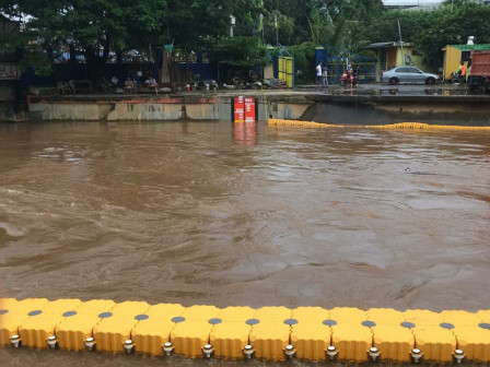
Water level at Manggarai Sluice Gate on Jalan Tambak, Menteng, Central Jakarta is decreasing. At 4 PM, water level at Manggarai Sluice Gate decreased to Alert 3 Status with height of 845 centimeters after previously reached Alert 2 Status.
We do our best in managing water to minimize impact of inundation or flooding
Jakarta Water Resources (SDA) Agency's Drainage Section Head, Firmansyah conveyed, water level at Katulampa Embankment was already in Normal (Alert 4) status with height of 50 centimeters at 4 PM.
Monitoring Manggarai Sluice Gate, Anies Urges All Ranks to Prioritize Residents Safety"We do our best in managing water to minimize impact of inundation or flooding. Water has also drained to Ciliwung Lama that leads to Gunung Sahari and Marina Water Gate," he informed at Manggarai Sluice Gate, Central Jakarta, Saturday (2/20).
He explained, Ciliwung River flow towards West Flood Canal (BKB) three gates are open full time according to standard operating procedures. While sluice gate that leads water flow to Ciliwung Lama River is situational, depending on weather, rain upstream and local rain. Currently, Ciliwung Lama River's sluice gates are opened as high as 250 centimeters, considering the sea level is receding.
"It is our effort to lower water level at Ciliwung Manggarai towards BKB thus Krukut River flow to BKB can be faster, because water levels at Krukut River and Mampang River are still high until this afternoon," he stated.
His side estimated water level at Marina Water Gate to reduce to the sea lowest point at 16:30. When the sea is receding, Ciliwung River flow will be channeled directly to the sea through Gunung Sahari and Marina Water Gate.
"From our monitoring, there is tide at Marina Water Gate this morning. In afternoon, it is decreasing thus it is hoped water flow through Ciliwung Lama River can flow smoothly," he mentioned.

