Spatial Planning Geographic Information System Application Officially Operated
Reported by Budhi Firmansyah Surapati | Translated by Maria Inggita
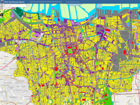
Jakarta Land Spatial Planning and Building Work (CKTRP) Dept. has launched Jakarta spatial planning geographic information system application.
Besides 18 types of information, this application has citizen reporting service feature
Jakarta CKTRP Dept. Head, Benny Agus Chandra said, application development is needed in order to provide public information disclosure to citizen who needs data and information regarding spatial planning, land, and building construction in Jakarta.
He explained, this application has 18 spatial planning data that can be accessed in site https://tataruang.jakarta.go.id.
Next Week, Council will Discuss DCKTRP Asset Inventory"This is officially operated yesterday. Besides 18 types of information, this application has citizen reporting service feature," he added, Friday (10/13).
He explained, provided information in applications consist of abandoned building and land survey map, building data distribution map, zoning map, city plan map, groundwater usage distribution map, city planning guidance map, patrol map, and construction survey.
Meanwhile, reporting feature is intended for citizen who wants to consult or report about building, spatial planning, or land in Jakarta. The application site is also integrated with Smart City.
"In the near future, we will put mall and market distribution map feature. For PBB, we plan to add it by the end of this month," he closed.


